Ghostly green lakes merge in Australian outback after 2 years of heavy rain — Earth from space
Where is it? Barkly Tableland, Australia's Northern Territory [ -18.595019720, 135.2699610 ] What's in the photo? A series of ephemeral lakes that have merged into a single body of water Which sate…
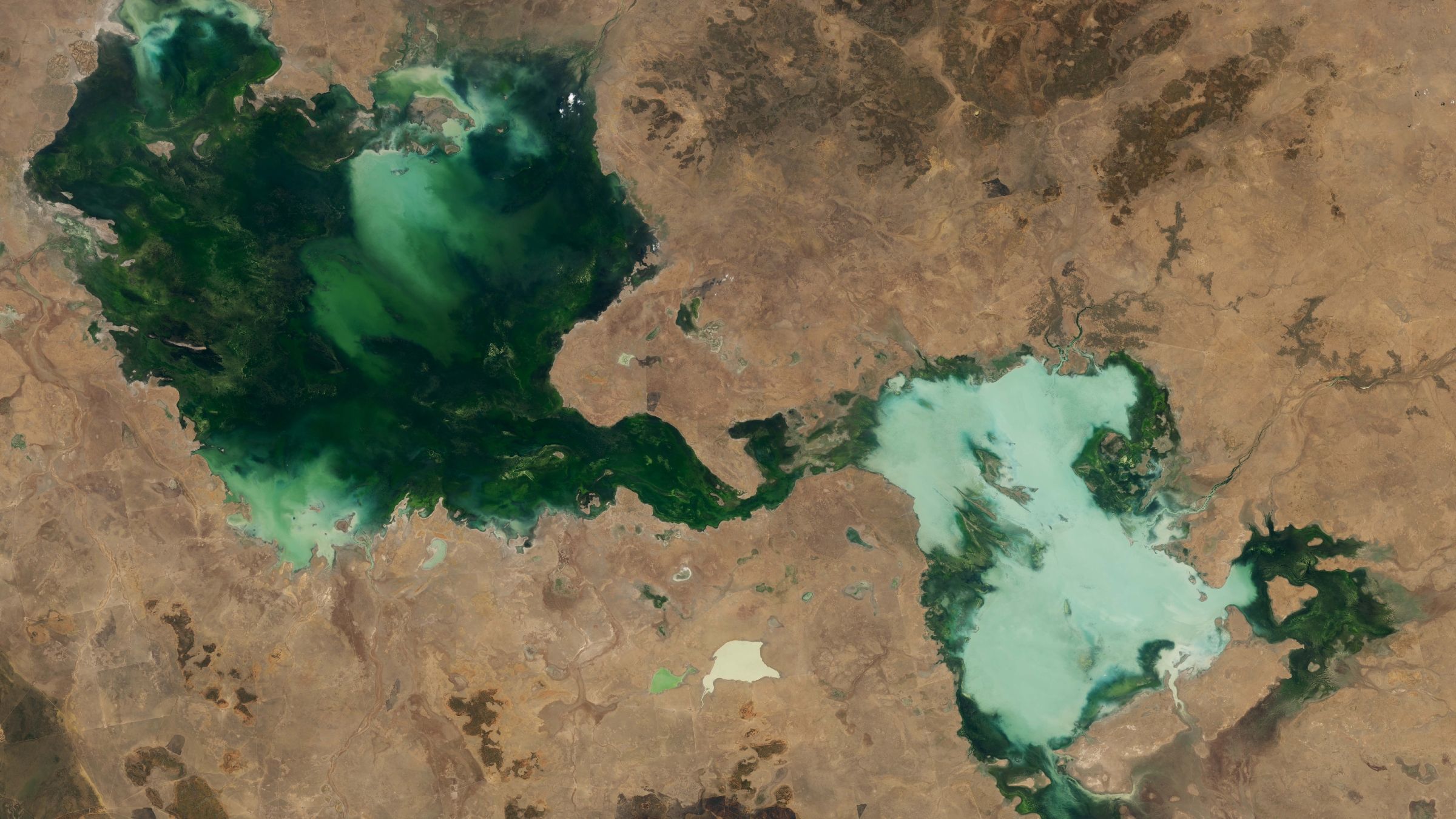
Where is it? Barkly Tableland, Australia's Northern Territory [ -18.595019720, 135.2699610 ]
What's in the photo? A series of ephemeral lakes that have merged into a single body of water
This striking satellite snap shows a series of ghostly green lakes that merged into a single murky entity after several years of unusual weather in the Australian outback.
The entwined lakes are located in Barkly Tableland, an area within Australia's Northern Territory, which lies between the states of Queensland, South Australia and Western Australia. The largest section of the conglomerate is Tarrabool Lake (on the left side of the photo), which stretches around 55 miles (90 kilometers) across at its widest point. It is dark green due to the dense vegetation and algae in the water.
The smaller half of the merged lakes (on the right side of the image) is made up of three lakes: Lake Sylvester, Lake Corella and Lake Deburgh. This section has a paler and chalkier hue due to high levels of suspended sediment. This is likely because the lakes have overflowed and mixed together, whipping up the dust and topsoil that once surrounded them. (Several other, smaller lakes of various sizes and shades of green can also be seen throughout the image.)
All of these lakes are ephemeral, meaning they have no constant inflow or outflow of water, much like most of Australia's other lakes . As a result, they almost completely dry out during prolonged periods of sunny weather, as high temperatures cause the water inside them to evaporate, and then reappear as heavy rainfall refills the basins.
However, across the two years prior to this image, there was so much rain that the lakes never dried out. Instead, they continued to grow year over year, as you can see from additional satellite imagery (see below), which shows the same area between 2022 and 2024.
The Northern Territory's rainy season lasts between October and April. Both the 2022-2023 and 2023-2024 rainy seasons, which preceded the 2024 satellite photos, were ranked among the top 10 wettest since 1990, according to NASA's Earth Observatory , which released these images.
Read Full Story at Live Science →